Property Record
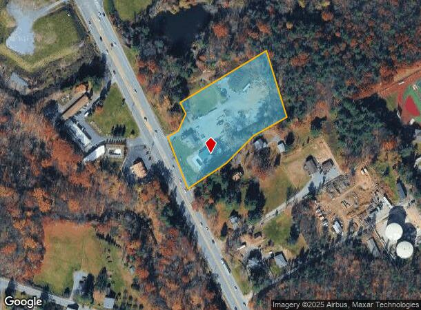
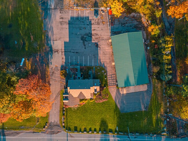
1819 Route 611, Mount Pocono, PA 18344


NEARBY LISTINGS FOR SALE OR LEASE
Property Detail
1819 Route 611
11.7.1.79
Dutchs Cycle Shop
Autorepair
Monroe
X
Pennsylvania
42089C0252E
3.33 AC
2025
Monroe County
2025
Philadelphia
300204
East Stroudsburg, PA
4,860 SF
DEMOGRAPHICS near 1819 Route 611
1 Mile
3 Mile
5 Mile
2024 Total Population
658
7,185
24,157
2029 Population
638
7,072
23,998
Pop Growth 2024-2029
(3.04%)
(1.57%)
(0.66%)
Average Age
46
44
43
2024 Total Households
277
2,929
9,146
HH Growth 2024-2029
(3.25%)
(1.57%)
(0.72%)
Median Household Inc
$88,709
$84,536
$80,977
Avg Household Size
2.40
2.40
2.60
2024 Avg HH Vehicles
2.00
2.00
2.00
Median Home Value
$223,276
$223,221
$203,750
Median Year Built
1978
1982
1984
Nearby Places
- Restaurants
- Banks
- Shops
- Fitness
- Groceries
PUBLIC TRANSPORTATION
AIRPORT
Wilkes-Barre/Scranton International
DRIVE
WALK
Distance
Wilkes-Barre/Scranton International
50 min
38.2 mi
Freight Ports
Maher Terminal
DRIVE
WALK
Distance
Maher Terminal
107 min
82.9 mi
SALE & LEASE HISTORY
LISTING DATE
SALE/LEASE

Jan 07, 2021
For Sale
Nearby Properties
Address
Land Use
TOTAL SIZE
Lot Size
Zoning
Address
Land Use
TOTAL SIZE
Lot Size
Zoning
133,654 SF
150.95 AC
C
Address
Land Use
TOTAL SIZE
Lot Size
Zoning
463,854 SF
95.86 AC
C
Address
Land Use
TOTAL SIZE
Lot Size
Zoning
1,132 SF
212.87 AC
I
Address
Land Use
TOTAL SIZE
Lot Size
Zoning
627,114 SF
896.17 AC
R-2
Address
Land Use
TOTAL SIZE
Lot Size
Zoning
11,060 SF
156.57 AC
R-2
Address
Land Use
TOTAL SIZE
Lot Size
Zoning
1,177,560 SF
77.25 AC
C-2
Address
Land Use
TOTAL SIZE
Lot Size
Zoning
133,288 SF
43.10 AC
R-2
Address
Land Use
TOTAL SIZE
Lot Size
Zoning
88,444 SF
19.57 AC
C-2
Address
Land Use
TOTAL SIZE
Lot Size
Zoning
690,000 SF
62.50 AC
I
Address
Land Use
TOTAL SIZE
Lot Size
Zoning
153,217 SF
18.14 AC
C-2
Address
Land Use
TOTAL SIZE
Lot Size
Zoning
208,764 SF
13.15 AC
I
Address
Land Use
TOTAL SIZE
Lot Size
Zoning
40,320 SF
17.79 AC
C
Address
Land Use
TOTAL SIZE
Lot Size
Zoning
64,756 SF
27.30 AC
R-1
Address
Land Use
TOTAL SIZE
Lot Size
Zoning
86,290 SF
6.15 AC
C-2
Address
Land Use
TOTAL SIZE
Lot Size
Zoning
15,484 SF
14.21 AC
C-3
Address
Land Use
TOTAL SIZE
Lot Size
Zoning
32,594 SF
1.43 AC
M
Address
Land Use
TOTAL SIZE
Lot Size
Zoning
6,710 SF
5.18 AC
C-2
Address
Land Use
TOTAL SIZE
Lot Size
Zoning
32,594 SF
3.57 AC
C-1
Address
Land Use
TOTAL SIZE
Lot Size
Zoning
5,274 SF
3.46 AC
C-2
Address
Land Use
TOTAL SIZE
Lot Size
Zoning
13,377 SF
2.99 AC
C-3
Address
Land Use
TOTAL SIZE
Lot Size
Zoning
1,344 SF
173.88 AC
PCRED
Address
Land Use
TOTAL SIZE
Lot Size
Zoning
24,360 SF
1.33 AC
C-3
Address
Land Use
TOTAL SIZE
Lot Size
Zoning
120,688 SF
20.39 AC
C-2
Address
Land Use
TOTAL SIZE
Lot Size
Zoning
6,164 SF
597.02 AC
RD
Address
Land Use
TOTAL SIZE
Lot Size
Zoning
103,912 SF
7.13 AC
I
Address
Land Use
TOTAL SIZE
Lot Size
Zoning
37,948 SF
47.53 AC
RR
Address
Land Use
TOTAL SIZE
Lot Size
Zoning
27,614 SF
36.14 AC
C
Address
Land Use
TOTAL SIZE
Lot Size
Zoning
1.32 AC
RD
Address
Land Use
TOTAL SIZE
Lot Size
Zoning
5,952 SF
21.50 AC
C
Address
Land Use
TOTAL SIZE
Lot Size
Zoning
4,696 SF
130.12 AC
B-1
The World's #1 Commercial Real Estate Marketplace
Connect with us
© 2025 CoStar Group
The information above has been obtained from sources believed reliable. While we do not doubt its accuracy we have not verified it and make no guarantee, warranty or representation about it. It is your responsibility to independently confirm its accuracy and completeness. Any projections, opinions, assumptions, or estimates used are for example only and do not represent the current or future performance of the property. The value of this transaction to you depends on tax and other factors which should be evaluated by your tax, financial, and legal advisors. You and your advisors should conduct a careful, independent investigation of the property to determine to your satisfaction the suitability of the property for your needs.